
5 Best Pub Walks on Exmoor: Historic Trails & Classic Inns
- Martin Hesp
- 1 day ago
- 12 min read

Updated: 9 hours ago
1. The Luxborough Circular: Wooded Coombes & Local Lore
The Pub: The Royal Oak, Luxborough

Luxborough really does offer some of the best walking country in the South West, surrounded by an extensive network of tracks that stitch together the three-part community of Kingsbridge, Pooltown, and Churchtown. This spectacular eight-mile circumnavigation begins at Kingsbridge, right near the village hall and the ancient, thatched timbers of the Royal Oak. Following the lane south to Pooltown before swinging up the steep Dunster road, you drop onto a track past Hall Farm that ascends gently through delightful meadows. High above, nestled beneath a giant cedar tree, sits splendid old Chargot—my home for over a decade, where the late Sir Edward Malet and I once shared long, decadent evenings over immense tumblers of Scotch, trading Boy’s Own tales of flying boats on the Nile.

Pressing on into the deep, wooded coombe of Chargot Wood, the route climbs westwards toward Collyhill Wood and the high crest of Kennisham Hill. A century ago, this peaceful woodland was a bustling industrial zone riddled with iron mines; today, an old chimney stack peering above the trees is the only obvious evidence left that such an enterprise ever existed in the middle of nowhere. Reaching the wide, breezy expanse of Lype Common, you are treated to a maze of rights of way. The path turns north, descending sharply into the quiet of the valley before making a short, crisp climb up to Churchtown.
IF YOU'RE ENJOYING THIS POST CHECK OUT OUR EXMOOR HUB PAGE FOR MORE EXMOOR IDEAS
Entering the graveyard of St Mary's Church, with its distinctive saddleback tower, is always a nostalgic journey down memory lane for me. Three of my old friends lie in this unspoilt resting place: dear Ned Malet, a man named George who operated in the world of clandestine intelligence, and an academic named Mike who famously left £500 behind the bar of the Royal Oak to hire a jazz band for his wake. Leaving these sober thoughts behind, you head west from the churchyard and cross three open fields to meet the massive, pine-crowned slopes of Croydon Hill—a soaring walking zone so vast you could hike it for a week and never take the same path twice.

Skirting the higher flanks of Perley Coombe, the route leads to a crossroads of tracks on the edge of Withypool Common, where a quick glance northward reveals a stunning panorama of the Bristol Channel and the West Somerset coast. From here, you turn sharp right to begin a long, steady descent down the eastern edge of the coombe, dropping through the border of pine forest and fields. The track guides you past the old Forestry Commission headquarters and onto the home stretch, leaving you just a short, quarter-mile stroll back to Kingsbridge. It is a walk guaranteed to build up a formidable thirst, best quenched by heading straight through the doors of the Royal Oak for a well-earned drink.
Walk Rundown
Start/Finish: Kingsbridge (near the village hall/The Royal Oak), Luxborough.
Distance: 8 miles.
Grading: Moderate to strenuous, with a few steep climbs up the coombes and forestry tracks.
The Route: Kingsbridge → Pooltown → Hall Farm track → Chargot Wood → Kennisham Hill → Lype Common → Churchtown (St Mary's Church) → Croydon Hill flanks → Perley Coombe → Kingsbridge.
Alternative Route (Longer): From Lype Common, head west to Heath Poult Cross, down to Old Stowey, and loop east past Throat Cottages and Westcott Farm.
Featured Pub: The Royal Oak, Luxborough.
Map: Ordnance Survey Outdoor Leisure 9 - Exmoor.

2. The Dunkery Beacon Loop: The Roof of the West Country
The Pub: The Rest and Be Thankful Inn, Wheddon Cross
It’s always good to have an excuse to walk on Dunkery because it is an Exmoor giant that boasts without doubt the best views in the region—a sweeping panorama stretching from the Pembrokeshire Coast all the way to the English Channel sparkling through the Sidmouth Gap. This spectacular loop pairs perfectly with a day out from the excellent Rest and Be Thankful inn at Wheddon Cross.

Ascending from the little car park at Rex Stile Head, the climb to the summit is easy going, offering a dramatic vantage point before you head west along the lonely, panoramic ridge path towards Great Rowbarrow.
This high country is steeped in haunting tales that linger in the mind as you walk. Look down over the remote vastness of Codsend Moors and you might recall the two wretched Huguenot ladies who fell on hard times and chose to perish here away from scornful eyes. Further down in Bagley Combe, the ruins of a plague-struck hamlet hide the tragic story of an innocent solitary man who took his own life after a cruel practical joke by drunken revellers from Porlock, leaving a ghost that ensured no one would ever live there again.
Yet the moor quickly shifts from the melancholy to the sublime as you roam down over Goosemoor Common and turn into Sweetworthy Combe.

This is a place to dream of when you are homesick—a secret rim where red deer graze silently, the rivulet tinkles like distant memories, and the lonely song of the skylark and harrier fills the air. It is a landscape alive with deep history, surrounded by ancient enclosures and settlements where archaeologists have unearthed the mysterious stone rings of early chieftains' huts.
Your return route follows the winding beauty of Dicky’s Path, passing the legendary waters of Birchanger Spring, once reputed to have healing qualities that stayed warm in winter and cold in summer. Eventually, the path deposits you onto the road just under Easter Hill, completing a loop that fills both the lungs and the imagination. It’s a walk that provides the ultimate excuse to head back to Wheddon Cross, pull up a chair, and toast the high moor.

Walk Rundown
Start/Finish: Rex Stile Head car park (on the Cutcombe to Luccombe road).
Distance: 6 miles.
Grading: Easy going along the ridges and combes, with a steep pull at the very end.
The Route: Rex Stile Head → Dunkery Beacon → Great Rowbarrow ridge path → Goosemoor Common → Sweetworthy Combe → Bagley Combe → Dicky's Path → Easter Hill.
Featured Pub: The Rest and Be Thankful inn, Wheddon Cross.
Map: Ordnance Survey Outdoor Leisure 9 - Exmoor.

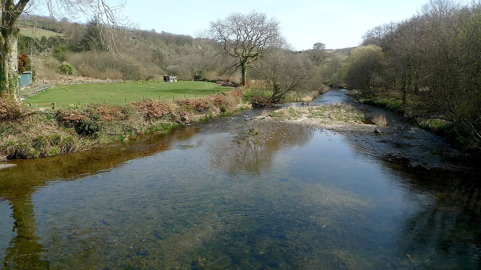
3. The Exford to Winsford Meander: Along the River Exe
The Pubs: The White Horse Hotel (Exford) & The Royal Oak (Winsford)
An eight-mile meander through the very heart of Exmoor, this atmospheric hike captures the true essence of the West Country moors, linking the hunting capital of Exford with picturesque Winsford. By following the River Exe along its loveliest section, where it cuts and curves through the great contours of the wilderness, you step right into prime red deer territory. It was along the crags of Curr Cleeve that I once saw a magnificent 'royal' stag lord it over the rocks like something from a Landseer painting—a quintessential icon of England's wilderness that leaves a wonderful, indelible image marked deep inside your mental film.

Before setting off from the bustling crossroads of Exford, pause to imagine the village on the catastrophic night of the August 1952 Lynmouth flood, when a wall of water rushed south from the high moors. It was here at the White Horse Hotel that Police Constable E.J. Hutchings saved the landlord's young son from the surging tide by famously hooking him onto a coat peg by his jacket as the water rose to the ceiling. Fortunately, you will encounter no such tidal waves today as you pass the village school and join the peaceful riverside track heading east toward the lonely old farm at Lyncombe.

From here, the Exe veers into the deep, steep, and beautifully remote sanctuary of Nethercote, an ancient Exmoor farmstead that feels as secluded as any dwelling in the West Country. Respecting the privacy of the people who live here, hikers follow the signposted alternative route through the meadows before eventually meeting the Winsford road. Rather than braving the tarmac, a riverside footpath escorts you straight into picturesque Winsford—an idyllic village that boasts both a welcoming tea-room and the thatch-roofed comfort of The Royal Oak.

For the return leg, the choice of high hills is yours, each offering expansive views that guarantee you'll be in the mood to wax lyrical by the finish. My preferred route climbs west out of Winsford up Bye Hill, diving down over Bye Common back toward Nethercote to retrace your steps along the valley. Alternatively, you can ascend up to Comer's Cross and follow the paths down over Room and Road Hills, dropping back into Exford just in time for a well-earned pint beside the fire at The White Horse.

Walk Rundown
Start/Finish: Exford village centre.
Distance: 7 to 8 miles.
Grading: Moderate. Easy going along the valley floor, with some steep, muddy climbs on the return over the common hills.
The Route: Exford → Lyncombe → Curr Cleeve → Nethercote meadows → Winsford → Bye Hill → Bye Common → Nethercote → Exford.
Short Shortcut: Turn up Kemp’s Lane at the end of the Nethercote track to Staddonhill Road for a direct, abbreviated return to Exford.
Featured Pubs: The White Horse Hotel (Exford) and The Royal Oak (Winsford).
Map: Ordnance Survey Outdoor Leisure 9 - Exmoor.

4. The Lynmouth & Countisbury Loop: High Cliffs & Viking Legends
The Pubs: The Blue Ball Inn (Countisbury) & The Rising Sun (Lynmouth)
If you had to choose just one coastal walk in this region that boasted truly stunning views, then the lofty lope around altitudinous Countisbury would, quite literally, be up there at the top of the list. High above Lynmouth Bay there’s not much save for St. John the Evangelist sitting snug on its shelf in the hills, and the Blue Ball Inn—an excellent, cosy roadside pub that serves as the perfect mid-walk refuge. Setting off from the picturesque harbour at Lynmouth on a fine sunny day with my wife and daughter, we headed up the inland path that hugs the northern banks of the East Lyn River. As the stream curves around Wester Wood, various paths strike upward through the trees, eventually delivering you onto the dramatic, high flanks of Wind Hill.

The summit of Wind Hill plays host to a remarkable legend concerning Ealderman Odda and the local Saxons who were chased up into the ancient hill-fort here by Hubba, the marauding brother of the Viking chief Ivan-the-Boneless. Believed to be the historic Arx Cynuit, this was where the trapped West Country men launched a desperate, suicidal charge that caught the Danes completely off guard. Hubba was killed, his feared Black Raven banner was seized, and today's hikers can ponder this bloody triumph while walking down the walled track toward the main road to join the spectacular South West Coast Path, where magnificent vistas of Lynmouth Bay unfold.

From here, you face a choice between a quick loop or a thrilling extension out toward the North Devon Foreland. The longer route presses east around Butter Hill, but be warned: the narrow coast path hugging the cliffside is strictly for non-vertigo sufferers. For a less alarming descent, you can follow the steep gut that drops east into Coddow Combe down to the Foreland Lighthouse.

The Trinity light still flashes automatically over the Atlantic, though the old keepers’ cottages have long since been converted into holiday homes.
The return journey from the lighthouse follows the paved access road all the way up to Barna Barrow, where a heather-clad footpath heads west across the moor back toward Countisbury. After an 1,100-foot climb, a long stop by the fire at the Blue Ball Inn is thoroughly deserved before you rejoin the coast path for the steep, breathtaking descent back down to Lynmouth. By the time you reach the harbor for a final pint at the Rising Sun, the massive dual climbs will have completely blown the cobwebs from even the most jaded of souls.
Walk Rundown
Start/Finish: Lynmouth Harbour (or Countisbury for a high-level start).
Distance: 6 miles (extended version).
Grading: Strenuous. Features two major 1,100-foot climbs and some narrow, precipitous cliff paths.
The Route: Lynmouth → East Lyn River path → Wester Wood → Wind Hill fort → Countisbury → Butter Hill (or Coddow Combe) → Foreland Lighthouse → Barna Barrow → Countisbury (The Blue Ball) → Coast Path → Lynmouth.
Vertigo Alternative: Skip the lighthouse loop entirely; head straight to the Blue Ball from Wind Hill, then return to Lynmouth via the main coast path.
Featured Pubs: The Blue Ball Inn (Countisbury) and The Rising Sun (Lynmouth).
Map: Ordnance Survey Outdoor Leisure 9 - Exmoor.

5. The Withypool & Landacre Circular: Heart of the High Moor
The Pub: The Royal Oak, Withypool
High moors in summer offer an exhilaration that is closer to heaven than any other parish in Somerset, and this splendid eight-mile perambulation captures that magic perfectly.

Beginning in the beautiful village of Withypool, where flower-bedecked lanes soon give way to frolicking lambs, you quickly pass through a gate and step out of man's ordered domain onto the wild, breeze-blown tops. Following the blue blur of a cobalt butterfly into a moorland dream, you climb north from the arched village bridge, twisting past private gardens and the old village school into the gently ascending meadows that lead to historic Kitridge Lane.

This ridge-back thoroughfare offers fine views at every step, made famous by the annual Exmoor Pony drive where the wild common herds are driven down to Foxtwitchen for scrutiny and branding. Looking north across Pennycombe Water, you gaze over the great, empty massif of Exmoor’s loneliest expanse, populated by nothing save for dolmen and deer. To the south, across the broad ravine of the River Barle, the eye traces the slopes of Withypool Common rising beyond the mysteriously named Tudball’s Splats toward Porchester Post. Walking a section of the Two Moors Way, you will eventually reach the massive, stone-walled traps used by the commoners to enclose the wild ponies when the drives come in.
Where the track divides out on the high moor near Pickedstones, the route takes the left-hand path to begin an easy, mile-long descent toward the sparkling waters of the Barle. Reaching the stream brings a bit of an adventure—and a confession: it’s time to get your feet wet. In dry weather, you can wade across barefoot through the surprisingly warm waters, though after heavy rains it's wiser to stick to the northerly bank. Crossing over brings you to Sherdon Hutch, a riverside knoll and favourite local wild swimming pool that does a fine impression of Paignton Beach on a hot summer’s day.

From the Hutch, you strike the road near the famous, multi-arched Landacre Bridge, where a rugged path heads east across the moors to escort you all the way back to town. It is hard to imagine the tenants of the old Royal Forest once gathering on these empty, bracken-covered banks to hold their ancient Swainmote court. In later years, the historic Court Leet wisely moved its business to the far more comfortable surroundings of the village. Following the river path straight back into Withypool, you can do exactly the same—repairing immediately to the wood-fired comfort of The Royal Oak to toast a perfect day on the high moor.

Walk Rundown
Start/Finish: Withypool village car park (just south of the arched bridge).
Distance: 8 miles.
Grading: Moderate. Features a steady initial ridge climb and a shallow river wading point.
The Route: Withypool → Kitridge Lane → Two Moors Way → Pickedstones moorland track → Barle river crossing → Sherdon Hutch → Landacre Bridge road → South bank moorland path → Withypool.
Welly Warning: The crossing at Sherdon Hutch requires wading; bring a small towel or opt to stay on the northern bank path down to Landacre Bridge during high water.
Featured Pub: The Royal Oak, Withypool.
Map: Ordnance Survey Explorer OL9 - Exmoor.

Frequently Asked Questions About Exmoor
What is the highest point on Exmoor?
The highest point on Exmoor is Dunkery Beacon, which sits at 1,705 feet (520 meters) above sea level. It is the highest point in Somerset and offers vast, sweeping views that, on a clear day, extend from the Bristol Channel and the Welsh coast all the way south to the English Channel.
Where can you see wild red deer on Exmoor?
Wild red deer roam freely across the national park, but they are most frequently spotted in the secluded river valleys and steep woods of the Exe Valley (around Exford and Nethercote), the quiet combes surrounding Dunkery Hill, and the deep oak woodlands of the Horner Valley.
What are the best traditional pubs for walkers on Exmoor?
Exmoor is famous for its historic, thatch-roofed inns. Some of the most celebrated for hikers include The Royal Oak in Withypool (ideal after a walk along the Barle), The White Horse Hotel in Exford, the ancient Royal Oak in Luxborough, and The Blue Ball Inn at Countisbury, which sits high above the coast path.
Is walking on Exmoor difficult?
Exmoor offers a diverse mix of terrain. While ridge-top paths like Kitridge Lane or the tracks around Luxborough offer relatively easy, level going, the landscape is defined by deep river valleys (coombes). This means many circular walks involve short, steep climbs out of the valley floors, and coastal routes near Lynmouth feature significant elevation changes. Proper walking boots and an Ordnance Survey map (Explorer OL9) are highly recommended.


