Bude Beach Walk: Crooklets, Northcott Mouth and Summerleaze Downs
- Martin Hesp
- 5 hours ago
- 4 min read

A Classic North Cornwall Beach Walk
People often ask why these walks haven’t come out in book form, and it’s a question I ponder over myself. Maybe one day they will - and when they are gathered together in their different geographic or subject areas, a good idea for one in the series would be a book focussing on hikes that include stretches of beach.
A true classic of this genre is to be found at Bude. It’s short and sweet - but oh so incredibly salty and invigorating that even a less than fit mate of mine joined me along its three humble miles this week and pronounced himself to have been reborn.
So how do we go about this extremely easy-to-follow hike that takes us gently up rolling down-lands only to drop us back to sea-level so that we can return a long the dead flat sands of a truly wondrous beach?

Well, the first thing to say is that we only go about it IF the tide is right. The great beach which stretches north of Bude is backed by numerous reefs that stretch seawards from the cliffs - and you could easily walk half way, only to find yourself cut off by an incoming tide. In one or two places this could be dangerous because the waves go right up to the cliffs - even if your name was Chris Bonnington you’d have no way of escape.
Summerleaze Downs and Crooklets Beach
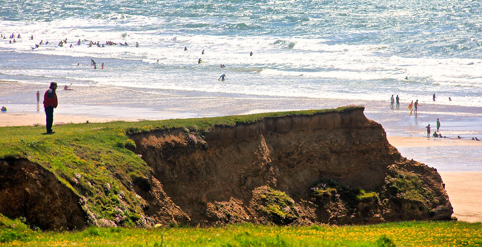
In the town of Bude there was a high-day-and-holiday atmosphere - the place seemed packed. Few though, were doing any traipsing - I’d say that fewer than one per cent of the crowd walked as much as half a mile along the great golden strand from the town beach.
All the better for us then, as we set out across the pleasant wide open space of Summerleaze Downs - a wonderful bit of open land that would be the envy of any seaside town. It is remarkable that this prime coastal location has never been built upon, though we must turn a blind eye to the large supermarket that dominates the Bude end of the big grassy sward.

Which is easy to do as we are heading in the other direction. We're now in what is grandly known as the Grenville Manor of Stratton - Stratton being a far more important historically speaking than tiny Bedes Haven - as Bude used to be known. Nowadays the roles are reversed and Stratton is really just a suburb of Bude.
We walk down across the grass to Crooklets Beach and find our way on to the South West Coast Path. Crooklets means 'barrow' and two tumuli survive north of the beach and there are occasional finds of Mesolithic waste.
Maer Down and Wrangle Point
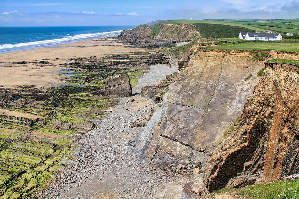
We're now on National Trust owned Maer Down and we climb quickly up to Wrangle Point which offers the most spectacular views of Bude. Careful as you go along here. The path is close to the unfenced edge and the Trust warns that, at normal times when stock graze on the Down, dog-owners should keep their pets on a lead as several frightened sheep are lost over the edge every year.
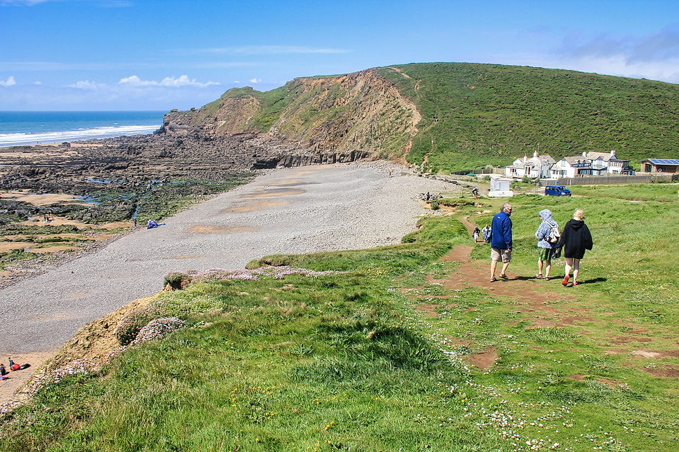
Northcott Mouth is an altogether more peaceful place after the busy seaside resort, and it is as good a location as any for a picnic or a rest. A stream tumbles down the valley onto the beach, and beyond that the coast path wends its way to Duckpool.
Returning Along the Golden Sands
As I mentioned, I was in the company of a friend who really needs to be a lot fitter than he is, so we elected to return to Bude along those easy miles of golden sand. But not before I had inspected a barnacle encrusted girder or two that, I believe, is probably all that is left of the Portuguese steamer Belem - wrecked here on 20th November, 1917.
I used the phrase ‘easy miles’ because, as readers will know, there are different types of sand and some does not lend itself to hiking. I am happy to report the grains at Bude are of the non-sinking variety - striding along here is as easy as walking along a pavement. You could even, if you wish, pick a bag of mussels from the rocks nearest the lapping sea. I did on a previous visit and very good they were too.
And so we walk on past Crooklets Beach to reach The Breakwater which was built in 1823 to protect the canal only to be destroyed by storm and built again in 1838. Here you can climb Chapel Rock which is, I am told, the "very soul of Bude" and then proceed inland to the only lock-gates which open directly onto the Atlantic Ocean.
The Remarkable Story of Bude Canal
The gates belong, of course, to Bude Canal which was built early in the 1820's to carry calcium-rich sea sand to the farmers up in the Cornish and Devon hill-country where the soil was poor. It was a magnificent engineering feat and stretched nearly 35 miles from Bude to Launceston.

All we needed to do now was stroll back into town to wherever it was we left our car, having enjoyed one of the best beach walks in the region.

Fact File
Start Point: Bude Visitor Centre, Crescent Car Park, between the canal and the River Neet.
Distance and Going: Just under four miles, very easy going – BUT make sure tides are right.
Further Information: The National Trust has a booklet called Bude to Morwenstow in which the geology, flora and fauna and history of the organisation's three local properties is described.

Bootiful Bude
If you’ve time take a turn around Bude’s town centre - it is one of those charming English seaside towns with lots of weird and wonderful independent shops.
Bountiful Bude
Make sure you grab a pasty in town. As far as the north coast is concerned Bude is the first major stop-off point as you enter Cornwall - and no visit to the Duchy would be complete without one of these savoury wonders.
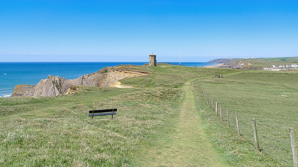
Boundless Bude
If you want boundless views to the south of town wander up to The Pepperpot on the cliffs. The curious octagonal structure was built in 1835 for Sir Thomas Acland but was later moved slightly inland because of cliff erosion.