
6 Great Walks on the Quantock Hills (and Somerset's Jurassic Coast)


There is nowhere in Britain quite like the Quantock Hills. Rising abruptly from the Somerset Levels and the Vale of Taunton Deane before tumbling straight into the Bristol Channel, England’s very first designated Area of Outstanding Natural Beauty (now a National Landscape) packs an extraordinary variety of terrain into a compact, ridge-backed peninsula.
Within an afternoon’s stroll, you can journey from deep, fern-hung sessile oak combes echoing with birdsong to wind-scoured heather commons where wild red deer roam and the views stretch across the water to the Welsh coast and west towards the high ramparts of Exmoor.
Here are six of the very best circular hikes across the Quantocks and its fascinating coast—ranging from lofty ridge scrambles and romantic literary trails to haunted combes and fossil-strewn shorelines.

1. Wills Neck & The High Ridge: The Quantock Summit
The steep descent down from the lofty summit of Wills Neck to the hamlet of Triscombe is the nearest West Country walking gets to flying. You feel that at any moment you could soar away across the vast West Somerset vale that lies far below. On the way down you can peer over at distant Dartmoor, take a discerning peek at the Blackdowns, examine Exmoor, and eyeball the Brendons.

Of course, being able to enjoy all this altitudinous sightseeing does come at a cost. As is the case with most high points, the price of the panorama is the climb up.
The Route
The Approach: Park in the lovely hamlet of Triscombe, tucked under the central massif of the Quantock ridge. Find the footpath leading off the small lane that runs along the hills towards Crowcombe.
The Flank Path: The path climbs the flank of the hill a little way to run parallel to the lane in a north-westerly direction between the lower woods and the high fields—an ideal spot for catching a glimpse of wild red deer.
The Climb: After about 1¼ miles, pass Little Quantock Farm and enter Little Quantock Combe. Here the hard work begins: the half-mile haul straight up to the top of the ridge is steep, to say the least.
The Ancient Drovers' Road: Once on the ridge, enjoy the wide vistas across the Somerset Levels (on a clear day you can see the Severn bridges). Head south-east along the unmade ancient drovers' track—known in a 13th-century document as Alferode—past Great Hill and the 2.5-foot-high monolith at Triscombe Stone.
The Summit & Descent: Just past the stone, take the path ascending gently uphill to the right to reach Wills Neck (1,260 ft / 384 m), named after the Ridge of the Wealas. After admiring the cairns, turn west for the vertigo-inducing, steep plunge back down through the woods into Triscombe.

Fact File
Start/Parking: Triscombe hamlet (approx. 7 miles north-west of Taunton).
Distance: 4 miles (6.4 km).
Difficulty: Moderate to strenuous (very steep ascent up the combe and a steep descent).
OS Map: OS Explorer 140 (Quantock Hills & Bridgwater).
Nearest Pub: The Blue Ball Inn, Triscombe. A thatched 17th-century country inn sitting at the foot of the hill, serving local ales and pub classics.

2. Dowsborough & Robin Upright's Hill: The Cuckoo Dome
Dowsborough is the lonely, wooded outcrop on the eastern flank of the Quantocks that stands apart from the rest of the bald, heath-capped hills along the ridge. Smothered in scrub oak woodland, this great green dome looks like a stately pleasure dome straight out of Samuel Taylor Coleridge’s imagination.

This is also prime territory for listening to—and occasionally spotting—elusive cuckoos flitting like small hawks over the scrub and open heath.
The Route
Start on the Ridge: Start at Crowcombe Park Gate (Grid Ref: ST 155 378). Traipse north across the flanks of Black Hill to pass Wilmot’s Pool—a peaty hilltop pool where deer slots in the black mud reveal where red deer come down to drink at night.
Down into the Combe: Continue north with Dowsborough looming ahead. The path descends steeply into Lady’s Combe, which separates Dowsborough from the main ridge.
Ascending Dowsborough: Cross the bottom of Lady’s Combe and take the track heading due north around the western contours of the hill, climbing up through the oak woods until the trees thin on the sea-facing side to reveal aerial panoramas of Steep Holm and Flat Holm.
The Iron Age Ramparts: Plough directly across the huge prehistoric earthwork crowning the summit—an irregularly oval univallate contour hill-fort enclosing seven acres.
Robin Upright's Hill: Head south-east across to Robin Upright's Hill. From here, swing west across the high heath avoiding the road, crossing back over Black Hill to return to Crowcombe Park Gate.

Fact File
Start/Parking: Crowcombe Park Gate car park (ST 155 378).
Distance: 3.5 miles (5.6 km).
Difficulty: Easy to moderate.
OS Map: OS Explorer 140.
Nearest Pub: The Carew Arms, Crowcombe (open daily for food and local ales at the foot of the hill).

3. Kilve Pill to Lilstock: The Burning Beach & Bombing Range
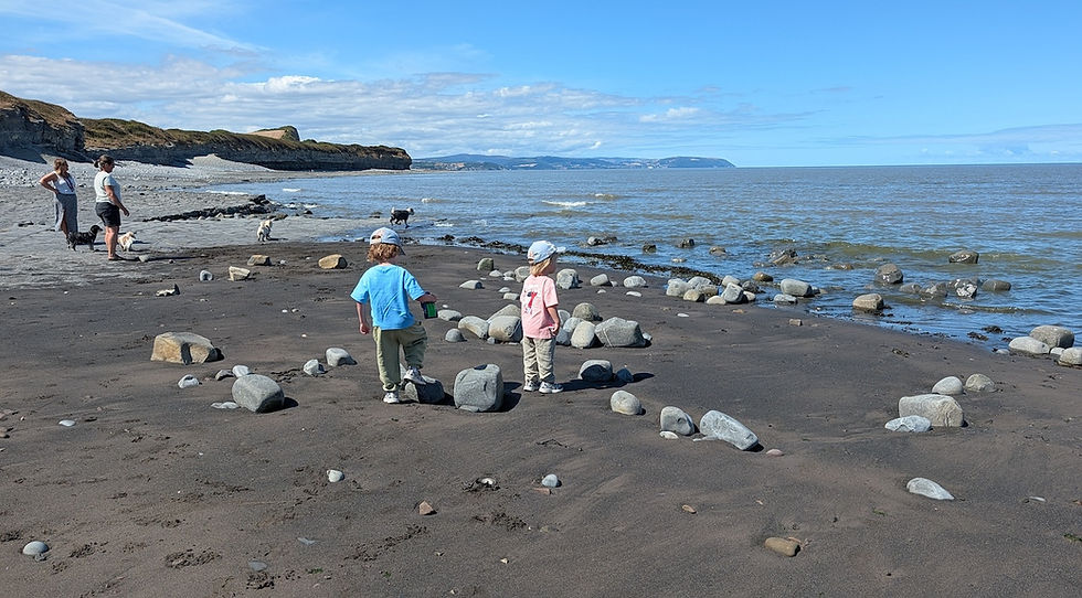
Out on the lonely claylands that lie under the northern Quantocks, the coastline along the Bristol Channel reveals one of the most remarkable geological shorelines in Britain.
Here, massive Blue Lias limestone pavements stretch out into the sea, laden with Jurassic fossils. The rock is so rich in shale oil that it once inspired an ill-fated 1920s distillation plant—and you can literally watch the beach rock catch fire if you place a barbecue directly upon the oil-bearing strata.
The Route
The Shoreline: From the centre of Kilve on the A39, head down Sea Lane past the 14th-century Chantry ruins to the car park at Kilve Pill. Take a moment to explore the rock pavements and the red-brick oil retort built in the early 1900s.
East Along the Cliffs: Mount the low cliffs east of the pill and follow the coastal path eastward. The cliff drop increases as you walk towards the white-painted Range Quadrant Hut—used by observers monitoring the offshore military bombing range.
Haunted Lilstock: Continue along the cliff tops with views across to the nuclear reactors of Hinkley Point on one side and the Brecon Beacons across the channel on the other. Arrive at Lilstock, a wonderfully lonely, atmospheric spot that once boasted a bustling harbour and pier.
The Return: Either retrace your steps along the clifftops to enjoy uninterrupted western views towards Minehead and Blue Anchor Bay, or make an inland loop through the hamlet of Lilstock, up past Kilton and Lower Hill Farm, and back down into the Kilve valley.

Fact File
Start/Parking: Kilve Beach car park (ST 145 444).
Distance: 3.5 miles (out and back) or 5 miles (inland loop via Kilton).
Difficulty: Easy, level walking.
OS Map: OS Explorer 140.
Fossil Rules: Hammering bedrock cliffs is forbidden (SSSI protection), but searching among loose beach stones easily reveals ammonites and Gryphaea.
Nearest Pub & Tea Room: The Hood Arms, Kilve (on the A39) for food and local cider; The Chantry Tea Gardens near the beach for afternoon tea.

4. Dead Woman’s Ditch, Quantock Combe & Seven Wells Wood
This hike explores the deep, moody combes of the central Quantocks and visits the scene of one of Somerset’s most famous historical crimes: the 1789 murder of Jane Walford by her husband Johnny, a local charcoal burner who was later hanged in chains at Walford’s Oak.
See walks around Dead Woman's Ditch and hikes inspired by The Last Broomsquire here

The Route
The Herepath: Park at Crowcombe Park Gate and join the ancient ridgeway (Herepath) heading south through magnificent colonnades of beech trees.
Down to Quantock Farm: Turn left off the ridge onto the footpath descending across fields towards Quantock Farm. Follow the right-of-way around the farm buildings, emerging onto the tarmac drive. Turn right and, after 300 yards, take the steep footpath on your left heading down into the woods.
Quantock Combe: Pass the mysterious spring known as St David's Well and follow the path down through Quantock Combe into the deep, conifer-clad valley basin often nicknamed "Little Canada".
Seven Wells Wood: Haul up the slopes of Seven Wells Wood via the steep track ascending across from the car park. The conifer plantations gradually give way to native scrub oak and ancient woodland.
Dead Woman's Ditch: Arrive at the ancient earthwork ditch that bears the grim name of Jenny Walford's murder site. Cross the road and head back to Crowcombe Park Gate via Wilmot's Pool, skimming past the legendary "Devil's Galloping Path".

Fact File
Start/Parking: Crowcombe Park Gate car park (ST 155 378).
Distance: 5 miles (8 km).
Difficulty: Moderate (one long descent and a steep climb out of the combe).
OS Map: OS Explorer 140.
Nearest Pub: The Carew Arms, Crowcombe or The Bicknoller Inn, Bicknoller (both active, open country inns serving food and local drinks).

5. Staple Plain, Beacon Hill & Bicknoller Combe
Staple Plain sits high above the village of St Audries, offering an immediate gateway into the northern Quantock wild without an exhausting initial climb. It is a wonderland of open heath, whortleberry banks, and sweeping panoramic views across West Somerset towards Exmoor and the sea.

The Route
The Great Road: From the Staple Plain car park, take the ancient track known as The Great Road across the eastern flanks of Beacon Hill (310 m). The track provides easy walking while the entire vale of West Somerset and the Bristol Channel open out behind your shoulder.
The Ridge to Thorncombe: Join the main ridge track heading south past Bicknoller Post to Thorncombe Barrow.
Plunge to Bicknoller: At Thorncombe Barrow, take the plunging path down through Long Combe to Quantock Moor Farm. Follow Trendle Lane into the picturesque thatched village of Bicknoller with its fine sandstone church.
Moor Fringe to Weacombe: Beat a retreat from the village lanes up to the moor gate at Bicknoller Combe. Follow the lower contour footpath running north along the boundary between the wild moor and the lower fields towards Weacombe. (Tip: tuck your trousers into your socks through the bracken to ward off deer ticks).
Weacombe Ascent: Turn into the deep red-sandstone cleft of Weacombe. Take the zig-zag path up the steep slanting moor or follow the plantation tracks through Staple Plantation back up to the car park.

Fact File
Start/Parking: Staple Plain car park, above West Quantoxhead (ST 116 410).
Distance: 4 miles (6.4 km).
Difficulty: Easy to moderate (one steep descent down Long Combe and an ascent out of Weacombe).
OS Map: OS Explorer 140.
Nearest Pub: The Bicknoller Inn, Bicknoller (in the village) or The Windmill Inn, West Quantoxhead (on the A39).

6. The Poets' Crossing: Holford, Crowcombe & Holford Combe
In 1797–98, William and Dorothy Wordsworth were living at Alfoxton House near Holford, while Samuel Taylor Coleridge walked over daily from his cottage in Nether Stowey. This classic crossing takes you across the entire breadth of the Quantock range from east to west and back again, passing through the deep, mossy ravines that inspired The Rime of the Ancient Mariner and Kubla Khan.

The Route
Entering Hodder's Combe: Start at Holford village green and car park. Take the path into Hodder’s Combe, tracing the bubbling, rocky stream under ancient sessile oaks—the "roaring dell" of Coleridge’s verse.
Up to the Spine: Follow the combe up to where the woodland gives way to open heath, mounting the main ridge track. Turn south along the spine with views stretching out over the sea towards Minehead until you reach Crowcombe Park Gate.
Drop to Crowcombe: Just before the road, take the sharp right footpath descending around the northern perimeter of Crowcombe Park, entering the historic estate village near Grime’s Farm.
Village & Carew Arms: Walk into the village for a well-earned lunch at The Carew Arms. Afterwards, wander past the ancient Church House and church; just past the school, take the footpath on the left up to the lane leading into Quantock Combe.
The Climb & Return: Haul up the steep track in Quantock Combe, skirting around Fire Beacon. Cross back over the road at Crowcombe Park Gate and head due north over Frog Hill. Descend the ridge dividing Frog Combe and Lady’s Combe into Holford Combe, following the stream all the way back to Holford.

Fact File
Start/Parking: Holford Bowling Green car park (ST 154 410).
Distance: 7 miles (11.2 km).
Difficulty: Moderate to strenuous (two good climbs and full ridge exposure).
OS Map: OS Explorer 140.
Nearest Pub: The Plough Inn, Holford (at the start/finish) or The Carew Arms, Crowcombe (at the halfway point).


